
Services
- Business Licenses
- Customer Self Service (CSS)
- FOIA Requests
- Food Trucks
- Waste and Recycling
- Historic Preservation
- Map Services
- Parking
- Permits
- Public Safety Education
- Service Requests
- Snow and Ice Removal
- Social Services Referrals
- Street Maintenance
-
Stormwater Management

- Stormwater Utility
- Tree Maintenance
- Utility Bill
- Vendor Self Services
Questions About Stormwater
Answers to common stormwater questions.
STORMWATER - General
Yearly maintenance operations include street sweeping, storm sewer inspection/cleaning, ditch repair and regrading, and repair and replacement of stormwater sewers located within Village rights-of-way.
The best way to report an area in need of maintenance is to submit a Service Request.
Green infrastructure encompasses a variety of practices, such as vegetated rooftops, bioswales, rain gardens, and other measures that capture and filter rain water where it falls.
The Stormwater Utility fee provides dedicated funding for the maintenance and improvement of the Village's stormwater system.
Upcoming stormwater/drainage projects can be found on the PROJECTS page.
The Stormwater Cost Share program offers financial assistance for flooding issues experienced by two or more properties. Funds are limited and allocated annually on a first-come, first-served basis, prioritized by the degree of flooding.

STORMWATER - Flooding/Floodplains
- If the flooding is an emergency, dial 9-1-1.
- For non-emergency: Call Public Works at 630.434.5460. M-F 7:30 a.m. to 4:30 p.m. Outside of these hours, please submit a Service Request.
Most homeowners or renters insurance policies do not cover flood damage. Only flood insurance covers the cost of rebuilding after a flood.
The Village participates in the National Flood Insurance Program (NFIP) which allows any property owner or renter to purchase flood insurance.
Because of the Village's Class 5 rating in FEMA's Community Rating System (CRS) program, Downers Grove property owners and renters are eligible for a 25% reduction in premiums.
The National Flood Insurance Act of 1968 made flood insurance available to anyone living in one of the almost 23,000 participating NFIP communities, including Downers Grove. More about NFIP.
The Village does not pump out basements.
The Village may pump out flooded yards on a case-by-case basis, depending on availability of staff and equipment. (See Resolution 2009-91)
The Federal Emergency Management Agency (FEMA) has delineated areas that have a 1% chance of flooding in any given year, commonly referred to as the 100-year flood plain or the Special Flood Hazard Area (SFHA). These areas usually flood during storms and typically border a creek or river.
There are many misperceptions that these areas only flood once every 100 years. This is actually a statistical probability that translates to a 26% chance of flooding within the life of a 30-year mortgage and a 67% chance of flooding within a span of 100 years. It is possible to have more than one 100-year flood in a single year.
- About the 100 Year Flood

LPDA stands for Localized Poor Drainage Area. The Village identified these areas as locations prone to flooding due to topography. In other words, LPDAs are areas of land that are bowl-shaped.
Stormwater runoff that cannot infiltrate the ground tends to accumulate in LPDAs, creating flooding or standing water. Although LPDAs are not recognized by FEMA, Village codes regulate both LPDAs and floodplains similarly.
Since LPDAs are already prone to flooding, the Village regulates construction in these areas to ensure that new structures do not contribute to existing issues.
 Using the Village's Parcel Navigator map:
- Enter your address in the search box in the upper left hand corner.
- Go to the bottom of the page and click on the "Layers" icon
 to open the list.
 - Click once on the box next to the Utility layer.
 The map changes color and makes the Floodplain and LPDA boundaries visible. If the Utility text is greyed out, this means you are zoomed out too far.

- Buildings constructed near, or adjacent to a floodplain or LPDA have restrictions regarding lowest opening elevations and basements. Please refer to Chapter 26, Section 505 of the Municipal Code.
- Any permanent structure, including swing sets and other playground equipment, requires a permit when placed in a floodplain or LPDA. Please refer to Chapter 26, Section 1303 of the Municipal Code.
STORMWATER - Creeks and Wetlands
There are about 12 miles of creeks running through Downers Grove. Not only are creeks integral parts of the stormwater system of our Village, but they also play a critical role in the quality and supply of our drinking water in general, by ensuring a continuous flow of clean water to surface waters and helping to recharge underground aquifers.
Creeks are dynamic, and will widen and meander over time. Erosion of the banks naturally occur, and serious erosion can compromise water quality. A streambank stabilization program, designed to repair targeted areas from existing erosion, and to stabilize them from future erosion, is part of the Village's Community Investment Program. Creeks may also be hosts to wetlands, floodplains, or LPDAs and you can use the Village's Parcel Navigator to get a general overview of your property to see if these may impact you as well. This tool should not be used as definitive proof of either subject and you are encouraged to call us at 630-434-5460 or email stormwater@downers.us to get more information.

Figure 01: St. Joseph Creek, North Streambank Stabilization Project - Before

Figure 02: St. Joseph Creek, North Streambank Stabilization Project - During

Figure 03: St. Joseph Creek, North Streambank Stabilization Project - After
Periodically the Village performs a streambank stabilization project for highly erodible areas. An easement is necessary to access the property and perform this work. If you are interested in granting an easement over your stream for potential future work by the Village, please call Public Works at 630-434-5460 or email stormwater@downers.us .
In July of 2015, the Village completed the St. Joseph Creek Streambank Corridor Assessment . This comprehensive study identified the level of erosion, areas of invasive species, and made note of areas requiring general weed and debris removal along the banks of St. Joseph and its tributaries through Downers Grove.
There are quite a few private and public wetland areas in Downers Grove of varying sizes. Wetlands are boggy areas that have specific types of soils and vegetation, and are particularly important for the type of wildlife and plants they support. In addition, they help with flood control and improve the quality of our groundwater by removing some common pollutants.

Pictured : Wetland at 40th and Glendenning .
While officially delineating a wetland requires analysis from an environmental scientist certified to do delineations, DuPage County has recently developed new informational wetland maps , identifying approximate boundaries and locations of wetlands in the county, with the help of a grant from the U.S. Environmental Protection Agency.
It is estimated that more than half of the country's wetlands have disappeared due to man-made causes. Since many wetland functions are difficult and expensive to replace, the Village's Stormwater & Flood Plain Ordinance requires that an applicant avoid or minimize impacts to wetlands. Any development proposed within 100 feet of a wetland may require a construction permit with the Village . It may also require additional permits and reviews at state and federal levels depending on the wetland affected and the work proposed.
Related Resources
A large percentage of creeks through the Village are on private property and it is up to the homeowner to perform basic maintenance. Here are some recommendations:
 Pictured: Algae on creek.
- Do not dump any chemicals or cleaners in the water that you would not be willing to drink. If it's not good for you, it probably is not good for the fish or plants.
- Do not place mulch piles or dump leaves in or near the banks of the creeks. Phosphorus released from the chemical breakdown of the leaves can increase the amount of algea in the water. Algae can significantly decrease the amount of oxygen in the water which can sicken or kill fish.
- Remove trash that collects in or around the water, and remove brush and branches that may fall in the water and cause damming, especially near storm structures.
- If you see a significant change in your section of creek, such as a sudden increase in erosion or a collapse of a bank, call Public Works at 630-434-5460 for an assessment email stormwater@downers.us .
- If there is no buffer along your section of creek at this time, please consider planting native perennials, bushes or trees in the area.
- Any development proposed within 100 feet of a wetland will require a construction permit with the Village. It may also require additional permits and reviews at state and federal levels, a wetland delineation and an impact study.
Below are some additional resources for homeowners related to creeks.
A riparian buffer is a strip of vegetation along a stream or wetland that helps shade the area, stabilizes and reduces erosion along the streambank, and partially protects a creek from the impact of adjacent land uses.

It also provides a habitat for animals that live near waterways. Unfortunately, there are many areas in our village where the riparian buffer has been mostly or entirely cleared, but maintaining a buffer is beneficial to the ecosystem of a creek.
Contact
National Flood Insurance Program
The National Flood Insurance Act of 1968 made flood insurance available to anyone living in one of the almost 23,000 participating NFIP communities, including Downers Grove.
More about NFIP.

Stormwater Credit and Incentive Manual
This manual outlines the basis for determining the extent of a stormwater credit or incentive and the conditions required to remain eligible.
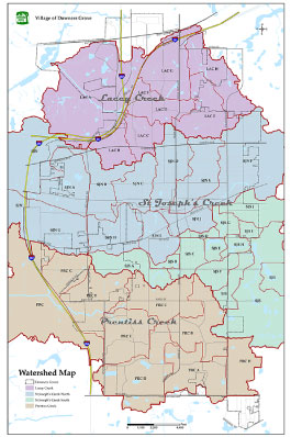
Watershed Map
This map shows the location and area of each of the Village's three watersheds.
Contact
National Flood Insurance Program
The National Flood Insurance Act of 1968 made flood insurance available to anyone living in one of the almost 23,000 participating NFIP communities, including Downers Grove.
More about NFIP.
Stormwater Credit and Incentive Manual
This manual outlines the basis for determining the extent of a stormwater credit or incentive and the conditions required to remain eligible.
Watershed Map
This map shows the location and area of each of the Village's three watersheds.
©2026 The Village of Downers Grove | All Rights Reserved