
Services
- Business Licenses
- Customer Self Service (CSS)
- FOIA Requests
- Food Trucks
- Waste and Recycling
- Historic Preservation
- Map Services
- Parking
- Permits
- Public Safety Education
- Service Requests
- Snow and Ice Removal
- Social Services Referrals
- Street Maintenance
-
Stormwater Management

- Stormwater Utility
- Tree Maintenance
- Utility Bill
- Vendor Self Services
Stormwater Management
Stormwater originates from rain or melting snow. Water that does not soak into the ground or drain off hard surfaces like driveways, sidewalks and parking lots becomes runoff. Every property generates runoff and benefits from the Village infrastructure system that manages stormwater. Without proper stormwater management, rain events may result in flooding on roads and properties throughout the Village, leading to property damage and dangerous road conditions. Stormwater runoff must be channeled through a system of pipes, ditches, catch basins and storm drains before being safely discharged into local streams.
The Village owns and operates a complex stormwater infrastructure system, consisting of:
- 8,700 drainage structures
- 315 detention facilities
- 140 miles of roadway ditches
- 150 miles of storm sewers
- 15 miles of streams
- 9 miles of culverts
All water is not the same. What's the difference?
Tap Water: Treated water that comes from a faucet and used for drinking, bathing, cooking, and household purposes. Service is provided and billed by the Village.
Wastewater: Water previously used for showering, washing clothes or flushing the toilet. Service is provided and billed by the Downers Grove Sanitary District.
Stormwater: Originates from rain, melting snow, or other outdoor activities (car washing, watering lawn, etc.). Water that does not soak into the ground becomes runoff, which is managed by the Village's stormwater infrastructure.
STORMWATER ASSISTANCE
Village staff is here to help with your stormwater and floodplain questions.
Contact us at 630-434-5460 or stormwater@downers.us.
What is a flood plain?
The Federal Emergency Management Agency (FEMA) has delineated areas that have a 1% chance of flooding in any given year, commonly referred to as the 100-year flood plain or the Special Flood Hazard Area (SFHA). These areas usually flood during storms and typically border a creek or river.
There are many misperceptions that these areas only flood once every 100 years. This is actually a statistical probability that translates to a 26% chance of flooding within the life of a 30-year mortgage and a 67% chance of flooding within a span of 100 years. It is possible to have more than one 100-year flood in a single year.
- About the 100 Year Flood

Is my property located in a flood plain or LPDA?
 Using the Village's Parcel Navigator map:
- Enter your address in the search box in the upper left hand corner.
- Go to the bottom of the page and click on the "Layers" icon
 to open the list.
 - Click once on the box next to the Utility layer.
 The map changes color and makes the Floodplain and LPDA boundaries visible. If the Utility text is greyed out, this means you are zoomed out too far.
What is an LPDA?
LPDA stands for Localized Poor Drainage Area. The Village identified these areas as locations prone to flooding due to topography. In other words, LPDAs are areas of land that are bowl-shaped.
Stormwater runoff that cannot infiltrate the ground tends to accumulate in LPDAs, creating flooding or standing water. Although LPDAs are not recognized by FEMA, Village codes regulate both LPDAs and floodplains similarly.
Why does the Village regulate LPDAs while FEMA does not?
Since LPDAs are already prone to flooding, the Village regulates construction in these areas to ensure that new structures do not contribute to existing issues.
Are there any restricted property uses in a floodplain or LPDA?

- Buildings constructed near, or adjacent to a floodplain or LPDA have restrictions regarding lowest opening elevations and basements. Please refer to Chapter 26, Section 505 of the Municipal Code.
- Any permanent structure, including swing sets and other playground equipment, requires a permit when placed in a floodplain or LPDA. Please refer to Chapter 26, Section 1303 of the Municipal Code.
Do I need flood insurance?
Most homeowners or renters insurance policies do not cover flood damage. Only flood insurance covers the cost of rebuilding after a flood.
The Village participates in the National Flood Insurance Program (NFIP) which allows any property owner or renter to purchase flood insurance.
Because of the Village's Class 5 rating in FEMA's Community Rating System (CRS) program, Downers Grove property owners and renters are eligible for a 25% reduction in premiums.
Contact
National Flood Insurance Program
The National Flood Insurance Act of 1968 made flood insurance available to anyone living in one of the almost 23,000 participating NFIP communities, including Downers Grove.
More about NFIP.

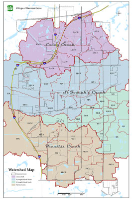
Watershed Map
This map shows the location and area of each of the Village's three watersheds.
Contact
National Flood Insurance Program
The National Flood Insurance Act of 1968 made flood insurance available to anyone living in one of the almost 23,000 participating NFIP communities, including Downers Grove.
More about NFIP.
Watershed Map
This map shows the location and area of each of the Village's three watersheds.
©2026 The Village of Downers Grove | All Rights Reserved